Sunday 10th February 2013
This wasn’t the lengthiest of visits, in fact at 32 minutes
it could be the shortest amount of time I spend on an island. Therefore I won’t
claim to be doing the Isle of Sheppey justice, but I’ll tell you what I saw.
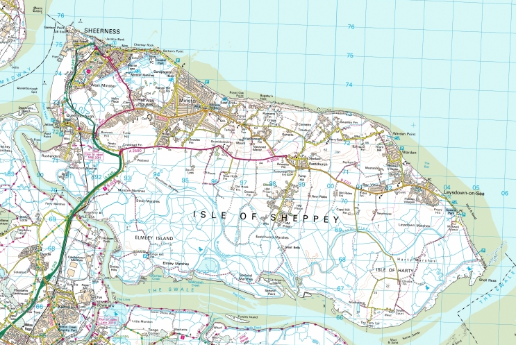
The Isle of Sheppey is at the mouth of the Thames Estuary and
also is to one side of the River Medway as it flows into the Thames, the Isle
of Grain being on the Northern side. It has a fairly rectangular appearance,
albeit slightly rounded, and is 36 square miles in area. Predomiantly flat, it
is believed the name Sheppey comes from the Anglo Saxon term Scaepige, meaning Sheep, a description
than remains precise today.


Sheppey has a rich history, evidence has been found of a
Bronze Age foundary, and the Saxons established a Monastery prior to AD675
which became home to the Queen of Kent. Later several Danish landings began
here, including in 1004, King Sweyn of Denmark, whose son was the more famous
King Canute of England. He spent much of his time at Shurland fortress on the
Island.
Later, the Isle of Sheppey holds the infamous privilege of
being the only part of inshore Britain to be successfully invaded, after the
Dutch occupied the island in 1667 and had the Dutch flag raised above the
courthouse at Queen borough.
In more recent times, shipyards dominated the Isle, until
the Royal Navy closed its dockyards in 1960. The Sheerness steel mill opened in
1972 and employed many hundreds of people, but has struggled more recently and
is currently closed, with hopes receding for a takeover and subsequent
reopening.
It’s hard to avoid the feeling you haven’t reached an island
if you don’t arrive by boat, or perhaps plane. It is easy to believe that some
kind of removal from the mainland is required, to achieve the sense of
isolation we often believe an island should give. The dictionary definition
does not require this, so I am going to try and look beyond this and treat each
place on its own merits.
On this occasion I was arriving by train, and by my
estimations there’s only Anglesey & Holy Island where I’m also likely to
arrive by train, so this is in fact England’s only mainland to island passenger
railway link.
The short journey on what is one of the South East’s few
remaining branch lines starts at Sittingbourne, and soon peels off the Medway
line to the right. This is a triangular junction but only a few peak trains
take the direct route to/from the London direction, the rest shuttling back and
forth, usually in the hands of a 2 car Class 466 unit, today being no
exception. The Sunday service is hourly but Mondays to Saturdays it is half
hourly. The hourly service gave rise to an awkward decision on arrival at
Sheerness-on-Sea, whether to spend 15 minutes or 1 hour 15 in Sheppey’s largest
town. I left that decision until my arrival.
The train was quiet, with 20 or so aboard. Average
temperatures on the Isle of Sheppey must be quite high for I overheard three
separate conversations relating to how cold it was. I’d say the temperature was
about 5 degrees but the locals seemed convinced that the second Ice Age was
forthcoming. Maybe this was wishful thinking seeing as any rise in sea level
could see them underwater. I can already see me getting sick of standard
British weather conversations. Another woman talked about her dog and how it
had been to see a dog psychologist to try and shed its fear of other small
dogs.
First stop was Kemsley, still on the mainland, where the
miniscule electronic screens display the departures for both platforms rather
than just the one they were stood one. A man ran onto the other platform before
realising the train wasn’t going his way, we stuttered away as the train
appeared to struggle to pick up power, whining, groaning, stuttering, but we
eventually got going.

Ahead was the flat expanse of the Isle of Sheppey, with a
slight wooded rise to our right, the view was punctured by pylons and
occasional scrubland, as well as some waterlogged patches. The dual carriageway
began to rise onto the new bridge. A more featureless bridge you are unlikely
to find, as if a 5 year old was ask to draw Daddy a big bridge, it simply rises
to a great height on massive concrete stilts and falls away again. No girders,
no cables, nothing. A triumph of function over form, but anything more majestic
would surely be out of place.
The old road then drew alongside as we pulled into Swale
station, a single platform as the two tracks have now become one. In terms of
railway isolation, you may have heard of the usual suspects; Dovey Junction,
Berney Arms, Rannoch Moor, in this travelogue age these places have become
destinations in themselves. Not so Swale. What purpose this platform serves is
not apparent, it stands guarding the river but now guarded by the behemoth
bridge above, with not a sign of any life anywhere near, not even a sheep. The
stop here is deeply mysterious, who would get on or off here? A walker who has
taken a wrong turning perhaps. Request stops were invented for locations such
as this.
 Almost immediately on departure we glide over the Kingsferry
bridge, which has parallel road and rail sections. The centre section rises vertically
between two N shaped towers on each side, each of predictably, concrete
construction. The bridge dates from 1960 and still rises to a height of 37m several
times per day, though the road traffic must be minimal since the adjacent
monster opened in 2006. Wikipedia appears confused on the history of the bridge
but it is clear there have been several bridges on the site since the first
railway bridge was built in 1860. It presents rather a brutal entrance to the
island, but certainly holds more charm than the adjacent road bridge. These
bridges are the only link to the mainland. To the unaware though, this could
just be a river crossing at around 70m wide.
Almost immediately on departure we glide over the Kingsferry
bridge, which has parallel road and rail sections. The centre section rises vertically
between two N shaped towers on each side, each of predictably, concrete
construction. The bridge dates from 1960 and still rises to a height of 37m several
times per day, though the road traffic must be minimal since the adjacent
monster opened in 2006. Wikipedia appears confused on the history of the bridge
but it is clear there have been several bridges on the site since the first
railway bridge was built in 1860. It presents rather a brutal entrance to the
island, but certainly holds more charm than the adjacent road bridge. These
bridges are the only link to the mainland. To the unaware though, this could
just be a river crossing at around 70m wide.
Onto the island itself, we scuttle onwards over the
featureless flat lads which are first dominated by sheep and then by a pick up
truck holding area. To the left, the north, the open view towards the Thames
Estuary provides a bit more light, highlighting more pylons and dockland
warehouses in the distance. An estate of 70’s council houses presented itself
on the right, but no signs of life were seen through the drizzle. Some railway
sidings drifted off to the left, disused but still visible through the
undergrowth. We smoothly stopped at Queenborough the large station building
still stands, cream coloured but would be better in brick, use unclear. Two of
the arctic monkeys who were complaining about the cold braved the icy
wilderness. It wasn’t long before we arrived at the left hand platform at
Sheerness-on-Sea. I walked to the end of the platform and made my way out
through the functional booking room.
The main road crossed in front, splitting in two to the right,
one branch down the narrow High Street, which contained many shops, but being
Sunday lunchtime, was deserted. A strip of land straight ahead led to the
seafront, so with limited time I made my way over the road and onto the path.
To my left were two ubiquitous British sights, which I wasn’t expecting too
much of on my travels, a McDonalds and a Tesco. Having said that, it was a
novelty to see them so close to a town centre rather than in some soulless retail
farm on a ring road. To the right of the seabound path was a large play area,
embedded deliberately in sand, but deserted on a miserable day like today. Then
further to the left, was the more grown up, and indoor version, containing
amusments, ten pin bowling, and Tantra nightclub. Bizzarely it was pumping out
some Coldplay, which was at odds with the flashing hyperactivity of the
machines inside, but apt in the greyness outside as I approached the sea wall.

It truly was a full palette of grey that unfolded before me,
the wide expanse of the Thames estuary just about fronted by a thin fringe of
pebbled beach. To my left a man kicked the stones with no real effort, as the
water lapped at his feet. I looked for the dog he was walking, but couldn’t see
one. The thin line on the Horizon to the left was Essex, but it was a long way
away, several ships appeared not to move between here and there, I figured that
Turner must have had a vivid imagination. This was not clearly an island
coastline, it was very much a mainland coastline, with cycle signs and dog
bins, concerete galore.

Time was pressing, and I had to make a decision to stay for
another hour or not, so I decided to take a peek down the High Street, to see
if this would be a worthwhile thing to do. As I retraced my steps, I noticed
the signposts appeared in French, German and Dutch, as well as English. A
hopeful gesture, I felt. I don’t think the Dutch will be repeating their
invasion any time soon, even on the Tourist front.
The High Street didn’t offer much to the casual visitor, at
this end at least, a couple of Charity shops, a newsagent, several takeways,
and a pub that I couldn’t tell whether it was open or not. I tend not to trust
pubs that have flourcescent starred card signs in any case. Further down the High
Street contained your national stores, banks, chemists, phone shops that could
be on any High Street in Britain.

I looked up where the nearest Good Beer Guide pub was, and
it was in the Blue Town. Sheerness has three parts, the Marine Town, the Mile
Town and the Blue Town, the OIdest, being at the tip of the island pointing
into the Thames. However, the thought of
a mile walk to sit alone in a pub didn’t entice, and I decided to make my way
back to station. As I did so, I passed a second hand electronics shop, and was
amazed to see a first Generation Mega Drive holding fort in the window. Must
have antique value now.
 As I arrived back at the Station, I took a look at the
community Noticeboard, which advertised Guided tours of the Island.
Unfortunately they were only on the 2nd Saturday of every month.
However, noticing they started at the Blue Town Heritage centre, I quickly
googled to see if I had found something to keep me occupied for a little longer
and perhaps justify that pint. Alas it is only open Tuesdays to Saturdays,
which left me persuaded the best thing to do was to get the imminent train back
to Sittingbourne.
As I arrived back at the Station, I took a look at the
community Noticeboard, which advertised Guided tours of the Island.
Unfortunately they were only on the 2nd Saturday of every month.
However, noticing they started at the Blue Town Heritage centre, I quickly
googled to see if I had found something to keep me occupied for a little longer
and perhaps justify that pint. Alas it is only open Tuesdays to Saturdays,
which left me persuaded the best thing to do was to get the imminent train back
to Sittingbourne.
As we moved back towards the Kingsferry bridge, I felt that
there was certainly more the Island to see, but the train journey and short
walk certainly gave me a good impression, this is an island that is really just
an extension of the mainland, but is certainly intrinsically linked with the
sea, and perhaps the island should trade on some of its historic elements more,
as nearby Chatham has done successfully. Certainly being flat and near to the
sea, it could prove decent walking and cycling territory, but visually the
landward parts are marred by industry so there is little to entice people over
the bridge at present. An interesting start to my travels nonetheless,
something I think will be a lot different from the forthcoming visits.
 VITAL STATISTICS – ISLE OF SHEPPEY
Mode of Transport – Train/Foot
Distance Travelled on Island– 8.1m
High Point – Did not cross a contour! So about 4m, on the
sea wall.
Population – 37,852 (2001)
Area – 36sq.miles
Largest Town – Sheerness on Sea
Highest Point – The Mount, 73m
LINKS
No comments:
Post a Comment